Thursday, July 14, 2011

DMZ

The second weekend of Kyle's trip we headed back to Seoul for a tour of the DMZ. The USO has a nice DMZ tour so I booked it for  Saturday. We left  right after school, and got to Seoul around 9 pm. After looking for motel, we found a pretty cheap one right by the station. This time we got Kyle his own room so we didn't have to hear him snoring (and the room was too small for three people.) We had to be at Camp Kim by 7:30 in the morning, so we went to bed right away. We woke up a little late, and Kyle wanted to shower, so we had to rush to get to the metro. We had lots of metro practice the weekend before, so we kinda knew what we were doing. Luckily when we got off the metro there were some other people who didn't know where they were suppose to go and we followed them to Camp Kim. Then we had to get on the bus for an hour ride north!

The first stop on the tour was Camp Bonifas just south of the demilitarized zone. This is the southern camp where the soldiers  who support the JSA live. We had to wait on the bus for about 10 minutes until the solider who was going to be our tour guide arrived. Then we got off the bus and went into this auditorium for a briefing about the tour and the DMZ.  We also had to sign a contract stating that the tour agency was not responsible for anything that might happen while on the tour. It just so happens that the anniversary of the start of the Korean war was the day we went on the tour!

Panmunjeom, also known as the JSA (Joint Security Area)'s function is to keep peace between the two countries and prevent the out break of war. Panmunjeom is a neutral site where North and South Korean soldiers both patrol. The North and the South have their own buildings. The blue buildings belong to the South and the gray to the North. 

This is the Freedom house and was built by the South Koreans in 1998 as a symbol of a peaceful reunification. It is meant to house family reunions of those separated in the war.

When we arrived at the JSA we had to follow some rules. We were not allowed to point of make any gestures in the directions of the North Korean Soldiers. They told us that they would be watching us very close and that they would also be recording us on film. They encouraged us to take lots of pictures of the Northern side, but we were not allowed to take any pictures of the southern side which was weird. In this pictures we are lined up in the Freedom house while our tour guide told us some of the things we could and could not do.  

Here is our group waiting for some north Korean tourists to exit a building. It is rare that North Koreans were on a tour, but because it was the anniversary of the Korean war, some of us got a rare glimpse.

Here's Kyle in front of one of the South Korean soldiers. They really have to stand like that all day!

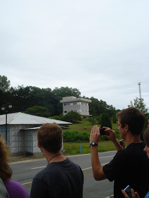
This is Panmungak, in  North Korean territory. This building is directly opposite of the Freedom house in the Southern territory. This is were the North Korean soldiers can observe the South.


We could see the North Koreans looking at us with binoculars in the gray building on the hill.


The Military Armistice Commission (MAC) building is in front of Panmungak, and serves as a conference hall between the North and the South. The meetings are held to discuss violations and help to keep peace. The meetings are not very friendly and they don't even greet each other when they meet. 

A North Korean soldier in front of the door on the left hand side.

Two North Korean Soldiers came down to get a better look at us as the second tour group came out of the MAC.

South Korean Soldier. He wears dark glasses to hide any emotion from the North Koreans. The solder in the background stands so only half of his body is visible to the North Korean soldiers. This allows less of a target if a North Korean Soilder where to shoot at him.

Here is out tour guide "Wilson" standing next to a S. Korean soldier in the MAC building. He told us that if you get to close to him he will make a gruting noise first. Then if you keep getting to close he will stomp and click his boots. THEN if you touch him....well he didn't really say what would happend but just smiled.


As you can see we were on the other side of the table. After talking about the soilders  and confrecne hall, our guide told us that one half of the table is where the South Korans sit, and the other side (that we are one) is for the North Koreans. So techinally we are in North Korean territory.

Here is a South Korean soldier on the Northern side.


Kyle and I in North Korean territory.


There are two villages located inside the DMZ. Daeseong-dong (Freedom Village), which is the South Korean village, and  the North Korean" Propaganda Village".  There are no inhabitants in the North Korean Village ( Gijeong-dong). If you want to read more about the village click on the Wikipedia link (it is really interesting!) 
http://en.wikipedia.org/wiki/Propaganda_Village


The Bridge of No Return. 

This is where the POW crossed back after the end of the Korean War.  Just across the river is the DPRK. The bridge is the only ground link between Pyeongyang and Seoul. 


The area of the Axe Murder Incident. This site is located close to the Bridge of no return.  Basically what happened was that there was a  tree that was blocking the view of the other side. The tree was clearly on the South Korean side, but the soilders who were trimming it were told to stop by a North Korean lieutenant. The American Captain Bonifas ordered the men to continue work. Suddenly the NK lieutenant shouted "Kill the Americans" and Captain Bonifas and another American lieutenant were murdered by an axe.  The incident only lasted four minutes before the North Koreans made their way back across the Bridge of No Return.  After this incident the four NK guard posts that were located on the SK side were removed and the two sides were no longer allowed to cross the MDL.

The Third tunnel. You can see the entrance into the tunnel in the background. There are four known tunnels dug under the DMZ by the North Koreans. The Third Tunnel is the largest and is only 27 miles from Seoul. It was discovered in 1978 and is about 1 mile long, about 6 feet tall and 6 feet wide. The tunnel would allow an army of 30,000 (equipment and all) to make it's way through the tunnel in an hour. 

I found this picture on Google so you could see what the tunnel looked like because pictures weren't allowed. 

Kyle at the DMZ!

Here is our last stop before lunch, Dorasan Observatory.  This is where you can get a good glimpse of North Korea.  There are telescopes for a better view, but the weather wasn't so good so they weren't in operation. 

Kyle snapped a picture of the inside of the observatory, even though they told us not to take  pictures.  Through the windows we could get  a good view of  "Propaganda Village." 

This is the cafeteria we ate at before going to Dorason Station.

Kyle getting mad at me for taking more picutes of him eating.


This is a jar in a case where we ate. As far a I can tell, it must represent peacful ties between the two Korean leaders, or be a commemoration of something, but I couldn't read the sign becuase it was in Korean =( Thats my best guess.

Some soilders at the entrace of Dorasan Station.


Dorason Station is the last South Korean stop on the Gyeongui line that used to connect North and South Korea.   It has recently been remodeled,  but there have been no trains running  since the north decided to close the boarder crossing in 2008. The station is only open for tourists. 


Gate to Pyeongyang 


Kyle walking the tracks on the way back to the bus. This trip was really intersting, and we learned a lot. I didn't really know what to expect the DMz to be like, but you can defenitly feel both peace and tension between the two countires. Our tour was conducted by the South, but I would be courious to see how they do the tour on the nothern side. The South promtes reunification a lot, but I wonder what the North's perspective are.

No comments:

Post a Comment